Central Meteorological Observatory: The possibility of typhoon "fireworks" heading north in Zhejiang offshore waters is not ruled out.
According to the latest forecast of the Central Meteorological Observatory, this year’s No.6 typhoon "Fireworks" will land on the northern coast of Fujian from the night of July 24th to the day of July 25th. It is expected that the landing intensity will be typhoon level or strong typhoon level (12-14, 35-42m/s). However, it does not rule out the possibility of going north in the offshore waters of Zhejiang.
Affected by it, Zhejiang, Shanghai, Fujian, Jiangsu, Anhui, Jiangxi, Taiwan Province and other places will have a wide range of heavy rain or heavy rain, and there will be heavy rain in the local area; There will be strong winds of magnitude 10 or above in the East China Sea and its adjacent waters and the coastal areas of East China. This will be the first typhoon in East China this year.
In addition, it should be noted that this year’s No.7 typhoon "Chapaka" has weakened into a tropical depression after landing, but its impact on South China continues, and it may be strengthened again after entering the Beibu Gulf in the future.
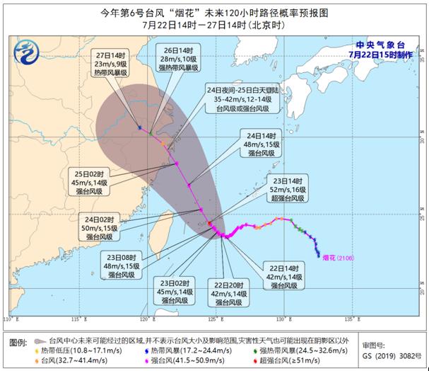
Probability forecast chart of typhoon "Fireworks" in the next 120 hours. Central meteorological observatory map
According to meteorologists, at present, there is tropical disturbance on the east side of typhoon Fireworks, and the development trend of its later intensity will affect the position of subtropical high, and then affect Fireworks. Therefore, the path and wind and rain forecast in the later stage of "fireworks" are uncertain. It is suggested that East China should pay close attention to the typhoon-related forecast and early warning information released by the Central Meteorological Observatory, make all preparations for typhoon prevention, and actively respond to urban and rural waterlogging, floods in small and medium-sized rivers, geological disasters of mountain torrents and gale hazards that may be caused by typhoon heavy rainfall.
At 14: 00 on July 22, Typhoon Fireworks was about 690 kilometers away from Wenling, Zhejiang Province. The maximum wind force near the center was 14 (strong typhoon level, 42 m/s), the lowest pressure in the center was 955 hectopascals, the radius of the seven-level wind circle was 220 ~ 300 kilometers, and the radius of the ten-level wind circle was 100 kilometers.
At present, "Fireworks" move to the north-north direction at a speed of 5 ~ 10 kilometers per hour, and then move to the southeast of the East China Sea on the afternoon of 23rd, then move to the northwest, and gradually approach the coastal areas from northern Zhejiang to northern Fujian, and will land on the above-mentioned coastal areas during the day from 24th to 25th, and it is possible to land on the north-central coastal areas of Zhejiang at the most, but it is not impossible to rule out the possibility of going north in the offshore waters of Zhejiang.
Gale forecast: It is predicted that the winds in the east of Taiwan Province, bashi channel, Taiwan Province Strait, East China Sea, waters near Diaoyu Island, Hangzhou Bay, Yangtze River estuary, southern Yellow Sea, northern and eastern coasts of Taiwan Province Island, central and northern coasts of Fujian, eastern and northern Zhejiang, Shanghai, southern and eastern Jiangsu will gradually increase to 7-9, with gusts of 10-12; Among them, there are 10 ~ 12 strong winds in the south and west of the East China Sea, the waters near Diaoyu Island, and the coastal areas of Zhejiang and Shanghai, with gusts of 13 ~ 14; The winds near the sea or area where the "Fireworks" center passes are 13 ~ 16, and the gusts are 17 and above.
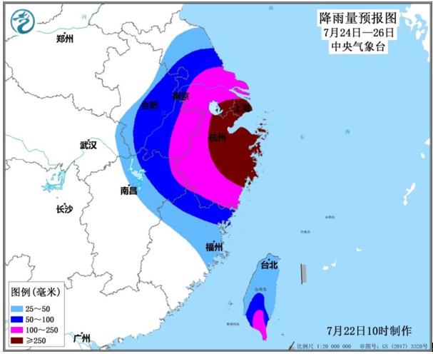
Rainfall forecast chart from July 24th to 26th. Central meteorological observatory map
Rainfall forecast: Affected by the typhoon "Fireworks" and the surrounding cloud system, it is expected that there will be heavy rains in most parts of Taiwan Province Island, northern Zhejiang and coastal areas from 22nd to 23rd, and there will be heavy rains or extremely heavy rains in some parts of Taiwan Province Island.
From July 24 to 26, there were heavy rains in southern Taiwan Province Island, northern Fujian, Zhejiang, Shanghai, south-central Jiangsu, south-central Anhui and northeastern Jiangxi, including heavy rains in parts of central and eastern Zhejiang, Shanghai, southern Jiangsu and southeastern Anhui, and heavy rains in northeastern Zhejiang and Shanghai. The accumulated rainfall is 60 ~ 120 mm, 150 ~ 300 mm in Zhejiang, Shanghai, southern Jiangsu and southeastern Anhui, and about 500 mm in the coastal area of northeastern Zhejiang. The maximum hourly rainfall in the above areas is 30 ~ 80 mm, and the local rainfall can reach about 100 mm.